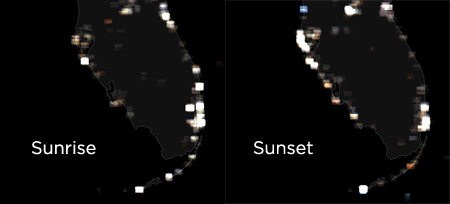
Sunrise, Sunset
I prepared these images by downloading about 42,000 thumbnail images from Flickr, and rendering them on these maps. Each image is displayed in the area where the photograph was taken. Bright spots correspond to metropolitan areas that accumulate a lot of photos.
If you pay close attention to the differences between the two photos, particularly Florida and the Great Lakes, you’ll see that people prefer to photograph the sun sinking (or rising) behind a body of water. Hence eastern-facing coastlines tend to accumulate more sunrise photos, and western-facing coastlines tend to accumulate sunset photos.
For the technically curious, I prepared the image using Perl and ImageMagick. The US state outlines come from publicly available US Census data, and I used the Perl library Geo::Coordinates::UTM for converting latitude and longitude to a UTM projection.
You can view the hi-res versions, in which you can make out the individual photos, here:
UPDATE: Daniel Drucker suggested plotting the states themselves, something he first did about two years ago, when Flickr first implemented geotags. Here’s my result:


October 29th, 2008 at 4:16 pm
http://3e.org/dmd/scents/archives/326 might interest you. It would probably be far more impressive these days – it was done within just a few days of Flickr supporting geotagging.
October 29th, 2008 at 7:05 pm
Very cool Dan! Definitely worth trying again…
October 30th, 2008 at 7:07 am
I tried your idea Daniel:
http://flickr.com/photos/krazydad/2986774792/
There are indeed a lot more dots to be drawn these days!